
Final Details for Eastern Moors on Sunday 15 November
Welcome to the third race of Peak Raid 2026.
The race visits the southern parts of the Eastern Moors, the areas around Big Moor, Birchen Edge, White Edge and more. Expect challenging route choices, good running on paths and tracks, and in places plenty of heather, marsh and tussocks.
Keep an eye on the weather with the Mountain Weather Information Service and dress appropriately for the conditions.
Check out the MWIS forecast for the Peak District
Race HQ is based at Baslow Village Hall, Nether End, Baslow, Derbyshire
Post Code: DE45 1SR Grid Reference: SK257721 What3Words: castle.freely.pickup
Parking and Travel:
There is a Pay and Display car park immediately next to the Baslow Village Hall. (£5.70 for four hours, cash or PaybyPhone App, location ID 806398). It is also possible to park within the village, but please ensure that you park respectfully and do not block driveways for local residents.
Please car share if you can. Parking in Baslow is limited.
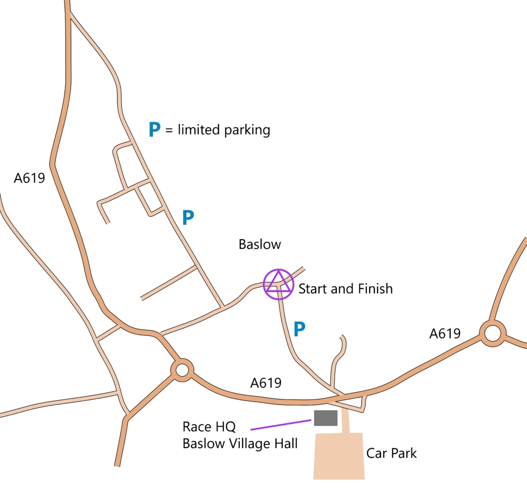
Android users: If the map below does not show, try refreshing or switch off, then back on Location Services.
Event Format:
If you are new to Peak Raid and have any questions – don’t be afraid to ask any of the organising team or drop us an email to info@explorerevents.co.uk
Peak Raid is a three-hour score event. The aim is to gain the maximum number of points by choosing your own route and visiting as many controls as you can within the three-hour time limit.
At the start, all competitors receive a waterproof 1:25000 map with the control locations and the points values clearly marked. The points value is within brackets, for example 12 (30) – Control 12 has a value of 30 points. Control points which are further away are generally worth more points.
For this event there are twenty-two controls, with a maximum possible score of 600 points. You choose your own route and go as hard or as easy as you wish, but remember, there is a three-hour maximum time limit, after which you lose points. So, don’t be late!
Late penalties are: 1 to 5 mins – 2 points/minute lost; 6 to 10 mins – 5 points/minute lost; 11 to 20 minutes – 10 points/minute lost; After 20 minutes – All points lost
Please remember the Golden Rules – do not climb fences or walls and you must report to Download even if you retire. If you know that you are going to be significantly late, please call Race HQ using the phone numbers on the back of the map.
Timing:
We use SI Timing software to record points and produce the final results. All competitors record their score using a SPORTident Card, which is more commonly known as a ‘dibber’.
Contactless (SIAC punching) is NOT enabled.
Entries and Registration:
Registration will be open from 7:30am. Start Times: From 8:00am until 10:00am. The course closes at 1:00pm.
All competitors must visit registration before going to the start. Including those competitors who have their own dibber.
To ensure a smooth a speedy registration process please:
- Complete the on the day registration safety form.
- Go to registration and collect your dibber, or competitors with their own dibbers take them for punch registration.
- For pairs – please come together to registration.
- Bring your kit with you as there will be a mandatory kit check before you can proceed to the start.
There may be limited entry on the day subject to sufficient maps and dibbers remaining unallocated. Late entries must contact the organiser in advance to check that there are sufficient maps and dibbers available. (Contact Paul on 07854067685)
Start and Finish:
The Start and Finish are both located 500m from Race HQ. See the map above – please arrive for your allocated start time.
Finishing – remember to punch the finish control and then go straight to Download to collect your results. Full results will be published on our website at: https://www.explorerevents.co.uk
Equipment, Kit Requirements and Conduct:
There will be a kit check for all competitors. You MUST wear or carry the following FRA Mandatory Kit and a survival bag.
If you do not have the correct kit you will not be allowed to start.
You MUST wear or carry;
- waterproof whole-body cover (with taped seams and integrated attached hood)
- hat and gloves
- map of the route (provided)
- compass, whistle and sufficient food for the event
- boots or fell running shoes that in the organiser’s opinion are fully suitable for the type of terrain
- a survival bag (bag not blanket, or bin liner)
The FRA leaflets: Requirements for Runners, Hypothermia and Hyperthermia are full of important information and recommended reading for all competitors taking part.
Emergency Contact and Competitor Safety:
We strongly encourage all competitors to carry a fully charged mobile phone and to register the phone for the Emergency SMS 999 text service. To register, simply text ‘Register’ to 999. You will then receive a reply. Respond with ‘Yes’, and you are set up to send messages to the emergency services from locations where there is little, or no mobile signal.
Pre-entering emergency phone numbers before the event is recommended. If you are going to finish significantly late, or if you are injured, call the contact numbers below.
Paul: 07854 067685 Andy: 07762630755
Terrain:
The Eastern Moors is an area of undulating open moorland with several gritstone edges offering fine views if the weather is clear.
Away from the tracks and paths the moorland terrain can be fairly marshy and rough, with heather, dead bracken and tussocks in places. There are many unmapped deer and cattle tracks. A significant area of tussocks has been indicated on the map with the vegetation boundary symbol, a continuous dotty line and a green vegetation screen.
On the map, Open Access is shown as yellow. Competitors can choose their own routes across Open Access areas.
Walls and fences are shown on the map with a black line and farmland is shown as white – you must not cross walls, fences or farmland. Ruined walls and ruined fences are shown with a dashed line with a dot and can be crossed.
Post Run Refreshments:
Tea, coffee and cake will be provided after your run. To reduce waste, you are welcome to bring your own cup and have a refill.
GPS Watches:
As per the FRA rules you cannot use a GPS watch to assist navigation for Peak Raid events. However, wearing a watch for tracking and post-race analysis is allowed.
Map:
PmAp 1:25 000 with 10m contours. The maps will be printed on waterproof paper and clearly display control points with a purple circle. Competitors may choose to visit control points in any order.
The control numbers and the points values will be displayed in the format 5 (20), where 5 is the checkpoint number and (20) the points value.
Control Points:
Control points are white and orange orienteering markers with a small red SI control box. If the SI control box fails (doesn’t beep or flash) please report at Download. Pairs must punch within one minute of each other.
Series Prize Giving:
We will be holding the series prize giving after Race 4 Alstonefield on Sunday 6th December.
Please check your series results are recorded correctly. Especially pairs and anyone with two SI Entries numbers.
For example, entering R1 as Billy Whizz & Minnie Minx and then R2 as Minnie Minx & Billy Whizz will produce two separate results, and will not show as the same pair in the results!
It is the competitors responsibility to ensure they enter with the same name format and SI Entries number for each race.
To be eligible for a prize, entrants must complete a minimum of two races. Prizes will be awarded to 1st, 2nd & 3rd places in each category. If there are six or fewer in a category, only 1st prize will be awarded. Age category is determined by age on the 31/12/2026.
If you are not able to attend the prize giving, please arrange for someone to collect on your behalf or contact us to arrange collection.
Dogs:
Unfortunately, due to the conditions imposed by landowners, the recommendations of the FRA and the potential threat to wildlife, livestock and fellow competitors dogs are not allowed.
Map Index:

Safety:
Your route will cross roads and follow short sections of road. Please take great care.
You may cross fields containing cows. If possible, keep your distance and pass around the outside of the herd. If the cattle react to your presence, stop running and walk quickly and quietly away. Avoid getting between cows and their calves. Don’t panic or run. Most cattle will stop before they reach you. If they follow – just walk on quietly. (NFU Advice)
Biosecurity:
We have been asked by Natural England to promote greater awareness of the risk of spreading disease.
Within the last few years there has been an increase in the number of new pest and pathogen outbreaks, which sadly, are having a negative impact upon the natural environment.
Running or walking through farmland and then into a nature reserve can increase the risk of spreading pathogens. Transporting organisms via soil and vegetation on shoes poses one of the greatest risks.
Please help to minimise the biosecurity risk associated with spreading pathogens from places previously visited by thoroughly cleaning footwear to remove organic debris before you go for a run or start an event.
Keep in Touch:
CONTACT: info@explorerevents.co.uk or Paul Addison on: 07854 067685
For the latest news follow us on Facebook:
https://www.facebook.com/PeakRaid
https://www.instagram.com/peak_raid/
Website:
https://www.explorerevents.co.uk
Email:
For the latest Peak District weather forecast: